Mobility Recommendations
Executive Summary
The Livable Communities Initiative (LCI) is Program #131 in Los Angeles’ Housing Element. It is a plan to address LA’s housing, traffic and pollution crisis by building 3-5 story residential buildings above small shops along carefully chosen commercial streets that are transformed to be walkable, bikeable and livable – creating “15 minute walkable communities.” A key component of the plan is to greatly reduce or eliminate onsite parking, which requires safe and pleasant mobility designed for “8-to-80 year olds.”
Experts
The LCI was developed by community members, stakeholders, experts in housing, mobility, architecture, urban planning, advocacy, and Labor. We worked with mobility experts from around the world to create a plan with the highest chance of success, with a focus on safety for children, and high quality of life. The most well-documented academic expertise is from Dutch universities and think tanks – who are generous in sharing their knowledge. Experts and research we draw from include: Chris Bruntlett, Dutch Cycling Embassy, Niels Van Oort, Associate Professor Public Transport at Delft University of Technology and is co-director of the Smart Public Transport Lab, Roland Kager, data analyst at Studio Bereikbaar and Urban Cycling Institute. Brett Atencio Thomas, the Active Transportation Coordinator of the city of Costa Mesa. Martin Tomasz (Systems Engines at Apple, and formerly Bird), and Lindsay Sturman (co-host of the podcast Bike Talk), coordinated the research.
World Class Mobility
Mobility comes in five main categories: (1) walking, (2) transit (3) bikes and micro-mobility, (4) Little Electric Vehicles (LEVs) and golf carts, and (5) cars. But high functioning mobility has to be designed and engineered effectively. Like a bridge that is designed to never fail, a plane that always flies, and an Apple product that is intuitive and engaging, streets can be designed so walking, biking and transit “scale” and people rarely drive. Using the best design and engineering, LA can create safe, pleasant dignified mobility that is empathetic to the user experience and will scale up so people will realistically choose to opt into a car light / car free lifestyle. When mobility is done poorly (like it is in almost every American city), people will continue to drive for the vast majority of their trips (90% of trips in LA are by car). But functional mobility is essential so we can build housing without parking.
Here is a guide to the best practices in mobility so residents of a Livable Community (and everyone adjacent) have a dignified, safe, pleasant way to get to everything they need.
Walkability
The elements of a walkable neighborhood are:
Small retail: streets with small shops and Neighborhood Serving Retail, like Larchmont Blvd, are already walkable (as opposed to a big box store like Staples). Lots of shops allow residents to do all of their daily and weekly errands by foot or bike – groceries, restaurants, coffee shops, mail shop, book store, hardware store and a pharmacy. One strategy is to focus LCI’s on LA’s Historic Main Streets and Villages already have fine grain retail and Legacy family businesses that have stood the test of time. LA was a city of 400 villages connected by trolleys, and their main streets still exist – Leimert Park, Westwood Village, Abbott Kinney – and they have small local shops, giving the neighborhood that “small town feel” that draws in pedestrians to stroll, sit, and shop. Almost any street with fine grain retail has the bones for an LCI.
Slow cars/No cars: Slowing or removing cars is essential for the walking experience to be pleasant. A street cannot be a freeway with cars going 50-70 mph (happens regularly on most corridors in LA), as well as a charming walking street.
Amenities: the city can add amenities such as a lush tree canopy, parklets, and encourage al fresco dining.
2. Transit
LA Metro is considered by experts to have “world class” transit infrastructure. High quality transit is defined as “fast and frequent” - and it scales up to significant ridership. If transit is slow or infrequent, it does not scale up to significant ridership – very few people will actually take it. A high quality bus route is simply a dedicated bus lane with frequent buses – achievable virtually overnight with paint. LCIs can help scale up our massive investment in Metro by building housing around our Metro stops, creating a TOD (Transit Oriented Development). The LCI can complement a traditional TOD – a circle around a high quality transit stop – and we can envision as a spoke, or a linear TOD:
3. Biking and Micro-Mobility
Micro-mobility includes bikes, adaptive bikes, e-bikes, cargo bikes, scooters, skate boards, and trikes (three wheels with a basket in back for groceries and more stability). It is essential to create a safe and pleasant “First Mile/Last Mile” connection for transit to scale up, because the data shows that if it’s not safe, 92-99% of people will simply opt-out. Unsafe, low quality bike lanes don’t scale past 1-8% (the “fit and the brave.”)
Bikes also expand the radius of a 15 minute commute:
Walking - ¾ mile
Bike ride - 3 miles
Ebike - 7 miles
Dutch research shows us what works to create cities where mode share is 40-60% and 90% of people bike (Utrecht). Bikeable cities are being replicated all over the world: Paris, London, Ghent, Malmo, Copenhagen and every Dutch city. Safe bike lanes come in two designs: with cars, and without cars:
With Cars
Bike lanes next to moving traffic need an extraordinarily high level of safety, design and engineering to keep people safe and separated from fast cars at all times. Here are guidelines based on Dutch design standards, and developed in conjunction with Streets for All for Caltrans to create a new classification for a safer bikeway design, aiming to unlock bike and micro-mobility options for the 60-90% of people who will bike if it’s safe:
Speeds of under 15-18 mph maximum, enforced by speed-cameras
3 feet barriers between parked cars and the bike lane to protect bikers from being “car doored”
Bikeways are “ingress-proof” by cars and fully protected with parked cars, curbs or level-separated only – no plastic posts.
Dutch (protected) intersections only - no “left turn bike lanes” or car right turn lanes where bikes cross into traffic
Phased bikeway signals, giving priority to those on bikes.
Design features that ensure cars slow down at intersections
NOTE: Even in the Netherlands, these bike lanes are still not considered safe for unaccompanied children
Without Cars
When cars are removed, minimal infrastructure is required – bikes can just be in the street. Allowances have to be made for some car access.
Pedestrianized street
ADA and local access only for cars
Cars are the “guests” (ie, they yield to everyone else) – aka, a Dutch “Woonerf”
Cobblestone or pavers signal to drivers this is not a thru-street
8.5-9 foot wide lanes to slow drivers down further
Concerns and drawbacks:
Bike lanes create a “bikelash” because they take away drive lanes and require much slower speeds than the typical LA commercial corridors, which is 25-35 mph (but tickets don't even start until 45 mph – and are essentially never enforced).
There are a few strategies to picking streets so car lanes can be removed, and cars slowed down:
Leverage existing street plans — we can leverage existing plans to pedestrianize streets that have already been vetted by the community and transportation experts to ensure that the impact on traffic will be minimal:
Heart of Hollywood (to close part of Hollywood Blvd)
Uplift Melrose (to slow cars and add bike lanes in the vibrant businesses district)
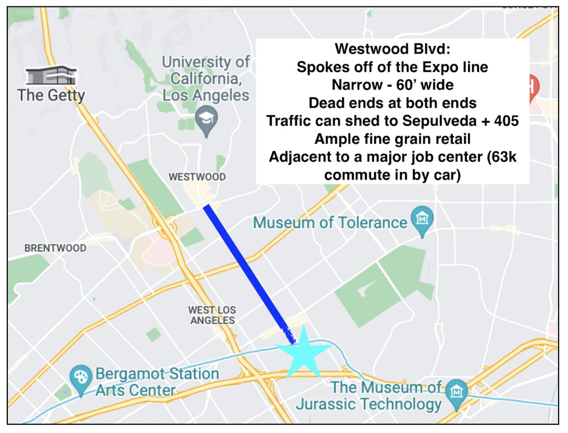
Focus on narrow, low car volume streets - major roads like Venice and Olympic are arteries through the city, carrying 6 lanes of heavy traffic. Instead of trying to calm those streets or impose a road diet, we can focus on streets that are narrower (Westwood is 60’ across, Pico is 80’, while Venice is 116’) and that dead end at one or both ends, and carry lighter loads that can easily “shed” to another street. Streets like these combine the elements: narrow, dead end streets with small, fine grain retail near transit and job centers:
Westwood Blvd - dead ends into UCLA, and turns into a small residential street at Pico
Abbot Kinney – short street
Hollywood Blvd - dead ends at both ends
4. Little Electric Vehicles (LEVs) and Gold Carts
LEVs (Little Electric Vehicles), NEVs (Neighborhood Electric Vehicles), Cantas and Golf Carts are exploding in popularity, especially with seniors. They have slower speeds and are lightweight, and pose minimal safety issues. LCI streets can have something called the “Slow Poke Lane,” which the Beach Cities are experimenting with – a slow lane just for golf carts and e-bikes. It is a great way to create communities that maximize mobility for all.
5. Cars and Carshare
Carshare: The LCI design can also include car share programs like Envoy. And peer to peer car sharing like Turo and Getaround is increasingly popular, and requires no special program from the city.
ADA: There can be accommodation for some cars for residents that have no other options. Most small lots (25-30 feet wide) can accommodate 1-2 parking spaces in the back for ADA and work vehicles.
Parking: Many neighborhoods have municipal lots nearby which can be an option facilitated in an LCI design plan.
Case Study: Westwood Blvd
Westwood Blvd is an ideal potential LCI street – it’s about 1.5 miles, has small retail, intersects with two high-quality Metro lines (Expo Line and Purple Line (future)), and it dead-ends at both ends – into Westwood Village (at the north end), and it becomes a small residential street (south of Pico). The 405 and Sepulveda are a few blocks away for traffic to move to. Westwood Blvd can be designed to mode shift away from cars so the city can actually see traffic evaporation on the Westside. The following are potential designs for the LCI street mobility on Westwood Blvd (between Santa Monica and Pico). The street varies in width from 80’ to 110’ (including sidewalks.) These designs are for the 80’ sections. The wider sections can have added traffic lanes, pedestrian amenities, etc.
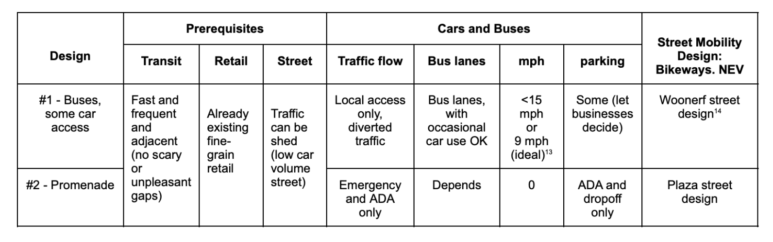
Design #1: Walkable and bikeable, with cars
This can be a transitional change. Transform the street to be like Larchmont – reducing drive lanes to one lane in each direction, slowing the cars, keeping parking, and widening sidewalks, and adding bike lanes.
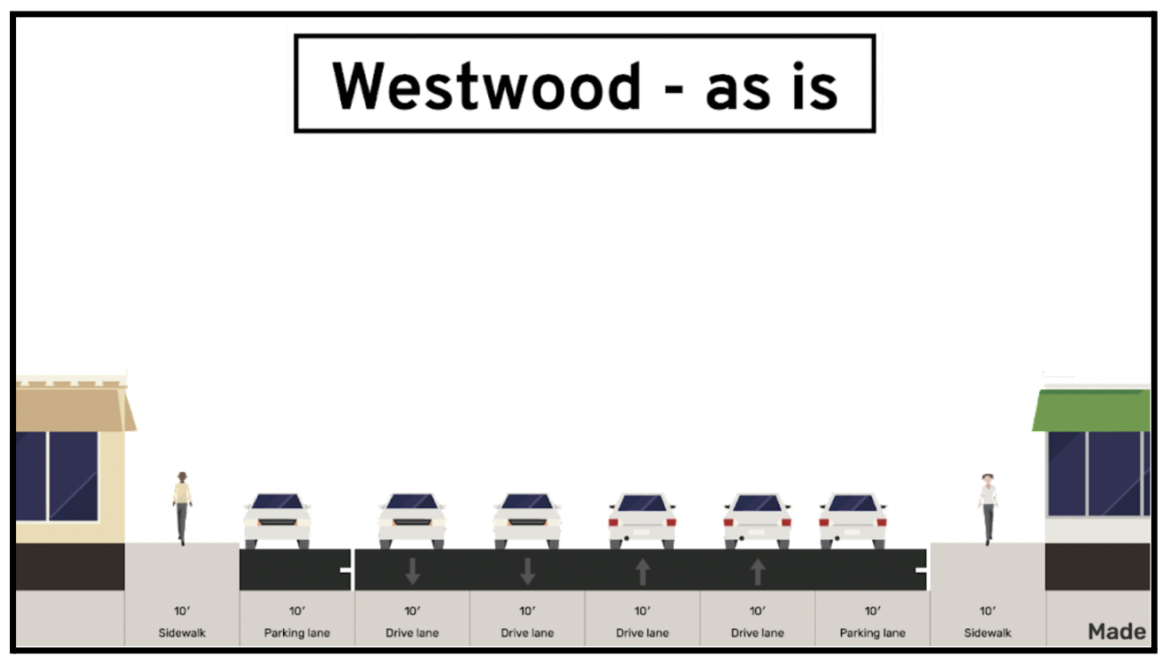
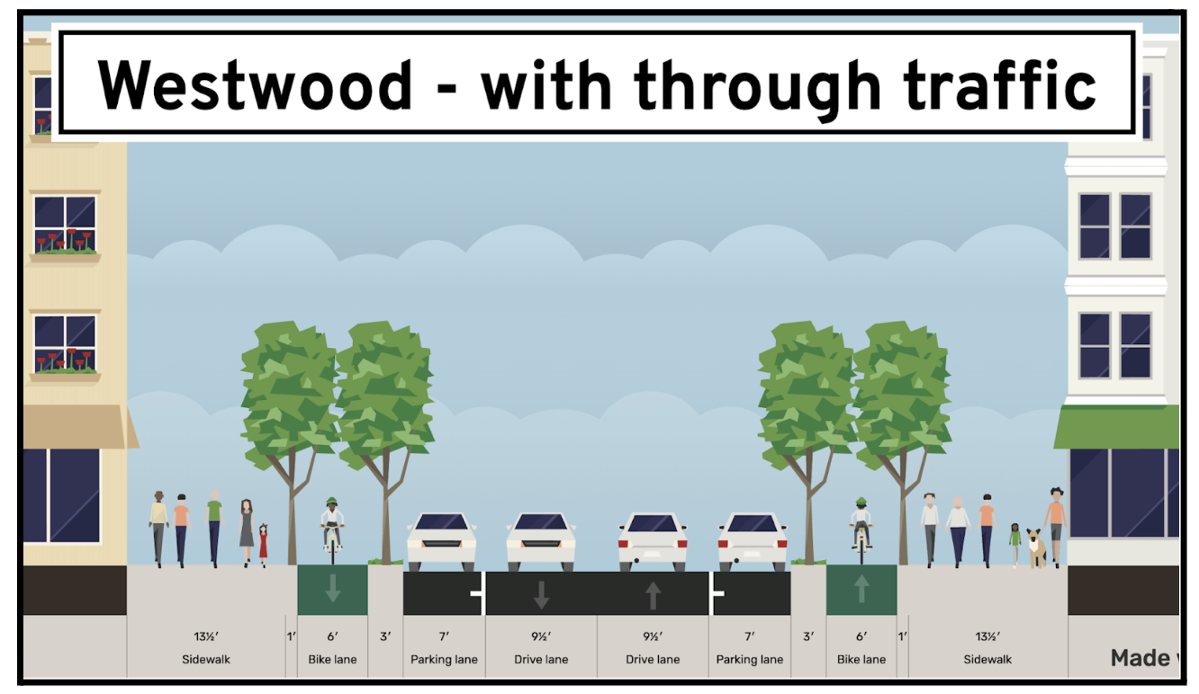
Design guidelines:
Cars:
Cars should be limited to under 18 mph, enforced with speed cameras and reinforced with narrow street design (9-9.5’ wide) and frequent stop signs
The traffic engineer’s metrics for the street are to minimize vehicle throughput
Bikes:
The proposed LCI bikeway design safety standard is a minimum requirement for this street design, to ensure equitable and safe bike mobility for all community members - adults, kids, older adults - not just the “fit and the brave”
Bike lanes can also be on either side
Require 3 feet barriers between parked cars and the bike lane to protect bikers from being “car doored.”
Design #2: Walkable and bikeable, with buses
This design has dedicated bus lanes, but keeps a flex space for drop offs (cars can drive in the bus lane for a few blocks but then are forced to divert.) The trade off allows for wide sidewalks, and bidirectional bike lanes:
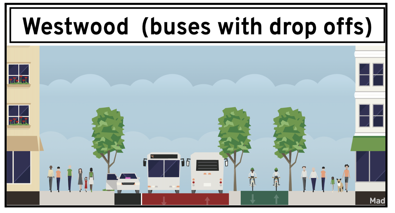
Design guidelines:
Transit:
Dedicated bus lane – buses are never stuck in traffic
Connects the Expo Line and the future Purple Line
Cars:
There is still parking and Flex Zones for drop-off, pick-ups, and deliveries, and vehicles are allowed for local access
Cars should be limited to under 18 mph, enforced with speed cameras and reinforced with narrow street design (9-9.5’ wide) and frequent stop signs
The traffic engineer’s metrics for the street are to minimize vehicle throughput.
Bikes:
The proposed LCI bikeway design safety standard is a minimum requirement for this street design, to ensure equitable and safe bike mobility for all community members - adults, kids, older adults - not just the “fit and the brave.”
Bike lanes can also be on either side
Require 3 feet barriers between parked cars and the bike lane to protect bikers from being “car doored”
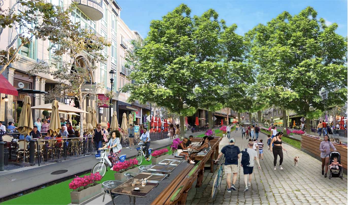
Design #3: Pedestrianized Promenade with bike lanes
A world-class linear park down Westwood, creating an invaluable amenity for all the residents.
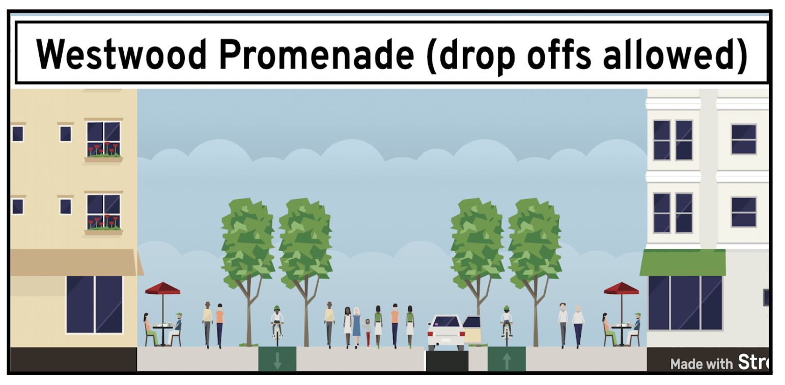
Design guidelines:
Cars: Cars are prohibited except for ADA, emergency and certain drop-off areas
Transit: A Metro stop is less than a 15-minute walk/5-minute bike ride from anywhere on Westwood Blvd.
Bikes: Bikeways conform to LCI’s design safety standard
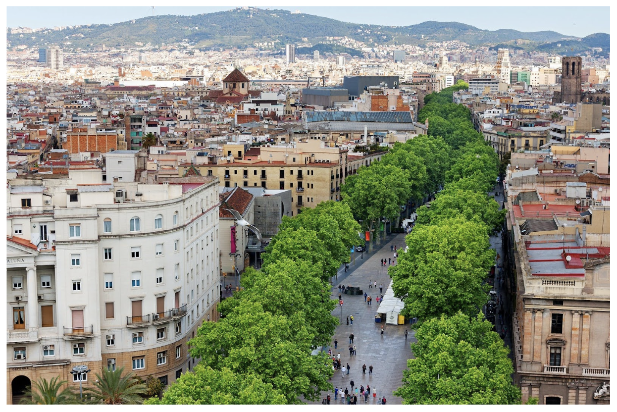
Promenade: The street becomes a promenade, or a linear park, also known as “city walk.” The city of Los Angeles does not have a pedestrianized street like Santa Monica’s Third Street Promenade, or Pearl Street in Boulder, CO, or Church Street in Burlington, VT. Promenades are increasingly popular across the world – famous examples include Las Ramblas in Barcelona, Rothschild Blvd in Tel Aviv. For a “park-poor” city like Los Angeles, such a street design is in itself a park. Amenities can include a tree-lined path for walking the dog, strolling with a child, a morning run. Park benches, al fresco dining, and a tree canopy.


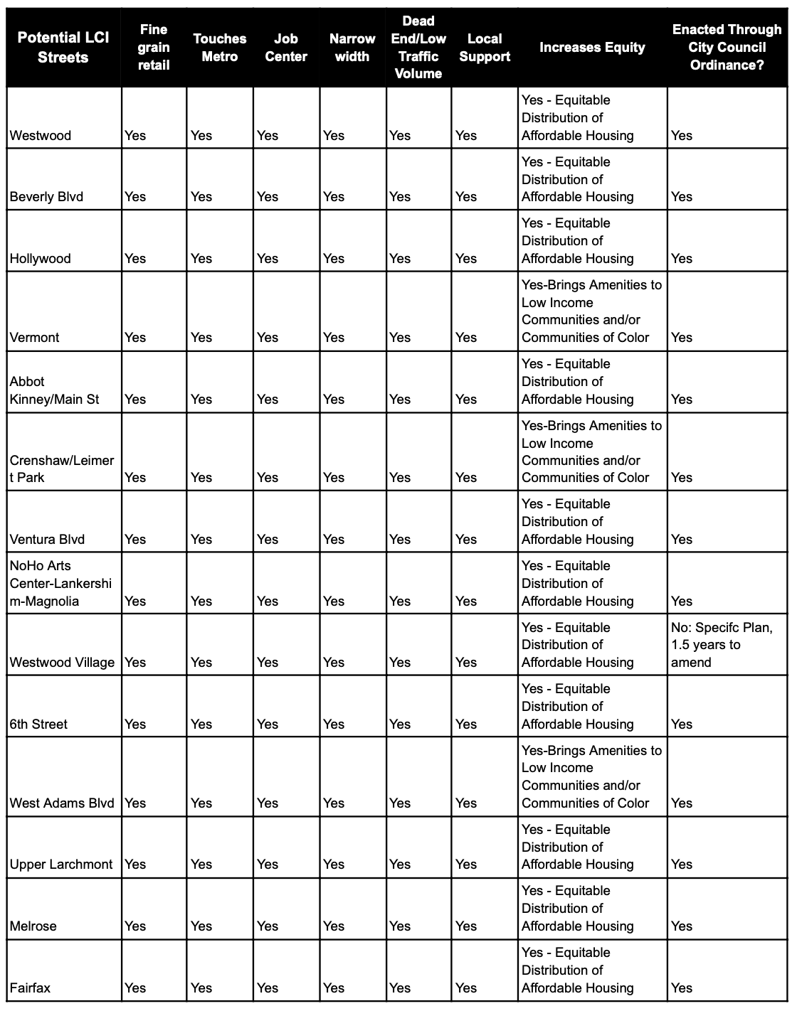
Analysis of Potential LCI Streets
This chart analyzes streets that have a high chance of working based on mobility experts, urbanists, guidance from elected officials, and have the following characteristics: Existing fine grain retail (and narrow parcels); touches Metro; adjacent to a major job center; the street has a narrow width, dead ends and/or carries a Low Traffic Volume’ has existing local support; increases equity; and can be enacted Through City Council by Ordinance without years of delays:
Summary of LCI Street Designs
Here is a summary of aspects of each design:
Beyond the LCI Street: Essential Mobility Corridors (EMCs)
Creating mobility corridors to get to the essentials
We know from cities all over the world it’s possible to live without a car, and it is some version of a “15 minute city” -- a walkable neighborhood with access by foot or by bike to daily and weekly necessities – grocery store, pharmacy, mail shop, cafes and restaurants, parks and playgrounds, as well as jobs, transit, and schools (here is a list of suggested amenities from Dan Luscher, founder of 15-Minute Cities.) Since LCI streets are by definition housing above small retail, already there will be plenty of the essentials right there. But not every street will have every essential, so we can also create “Essential Mobility Corridors” (EMCs) to access essentials nearby.
In the diagram (below), Westwood is an LCI Street (shown in solid green): housing above neighborhood serving retail, with walkability and micro-mobility. But there are no public schools and transit along Westwood Blvd, but they exist nearby. An Essential Mobility Corridor (green dotted line) can create critical routes of travel for LCI residents, connecting the LCI Street to essential daily destinations – in this case four public schools, and the Expo Line transit stop, as well as the job centers in Westwood Village (UCLA, the medical centers, etc), which would now be accessible by bike, cargo bike or NEV for anyone living on a Westwood LCI.
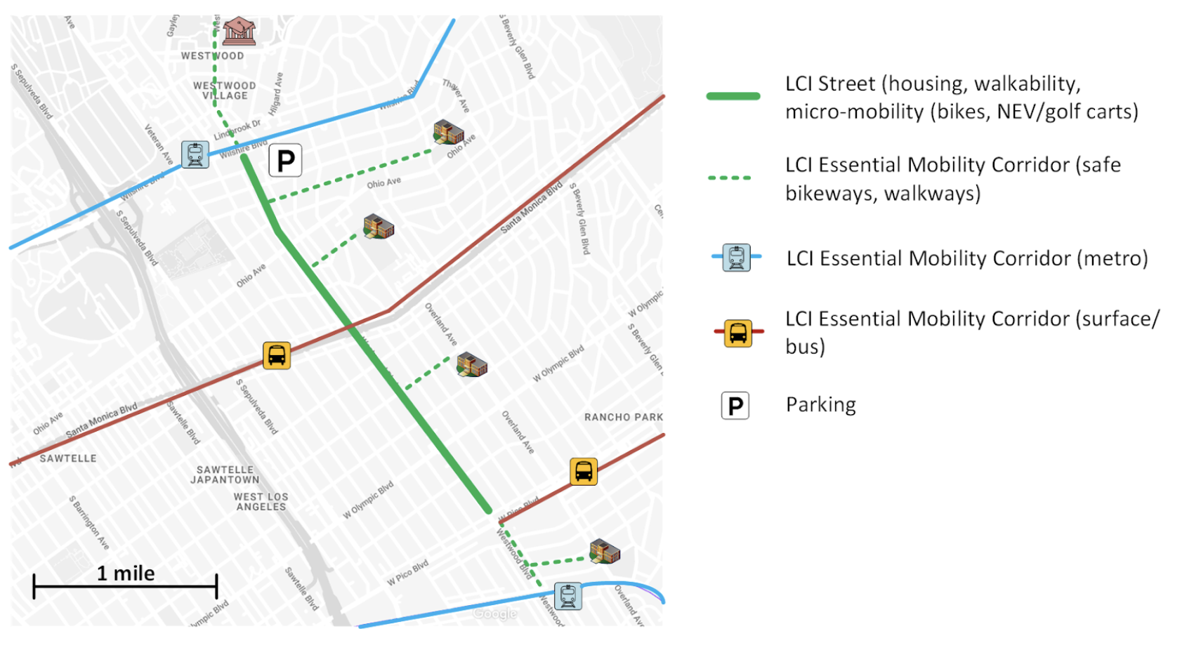
EMC - Walking and Biking: Designating a street as an Essential Mobility Corridor (EMCs) can create a safe route to schools, transit or job centers that radiate off an LCI street. The quality of a walk and the safety of a bike ride is important: no one wants to spend an hour with a small child walking along this street, with cars speeding past, navigating active driveways and major intersections; or biking, terrified of getting hit by a car.
LCI places a high importance on bikeways, because we predict bikes will be a primary transportation mode for residents that choose to live in LCI neighborhoods. The popularity of scooters in LA speaks to this prediction. While cars are LA’s #1 form of transportation (90% of our trips), in terms of freedom and convenience – getting you where you want, when you want – bikes are second to cars – and in some ways better. It’s exercise, you never get stuck in traffic.
The only barrier to biking is safety – ie, fast cars. To address this, LCI, together with Street For All, are advocating for improved bikeway standards at the state (Caltrans) level.
EMC - Metro/Buses: LCI residents also need access to ample public transit options. Metro can prioritize LCI streets as a place for high quality transit lines (ie, newly created dedicated bus lanes) to either run along, or intersect with (ie, EMC - Metro/Bus). Our housing deficit of 500,000 homes is a crisis, and it’s also a chance to reimagine car-light/car-free communities and create a world-class mobility system.

The good news is an LCI that “touches” Metro means residents have access to a substantial number of major job centers: DTLA, Santa Monica, Culver City, Westwood/UCLA/Medical Center, USC, the Wilshire corridor, Hollywood, etc.
One way to save scarce road space is the Albuquerque Bus Bulb Design
The Importance of Street Design for Equity
LCI Streets are calmed streets, with a design prioritized for housing - quiet livability, added greenspace, and walkability - rather than vehicle throughput. The street changes are important for equity – there are serious safety, equity and health concerns with putting affordable housing along high-volume streets. Noise and pollution have serious health consequences, and speeding cars present serious safety risks. Fast cars also squeeze out all other forms of mobility, making it unpleasant to walk, dangerous to bike, and too congested for buses to achieve significant ridership – forcing people to spend over 30% of their income on a car ($7,000-$10,000/year).
LCI car-light living is not for everyone, but we believe that if designed with care and empathy, we can create communities for people to live and thrive. It is essential for the climate that we cut our VMT by 25%; people who live car-free are doing everyone a favor for traffic, climate and air quality – and they deserve a high quality of life and to feel safe. The LCI housing is designed around equity.
The Role of Parking
Parking is one of the main causes of our housing crisis. It ruins both the affordability and profitability of a building. Parking destroys the affordability in two ways: (1) it raises rents (~$225/month) and (2) it incentives developers to build bigger units to amortize the cost of the parking – further making units not affordable. Parking destroys the economics of housing in four ways: (1) Parking is expensive to build ($75k+/spot). (2) Building podium parking or underground parking requires large parcels to build ramps and create space to turn cars around (42’) – requiring lot assembly that takes time and drives up the cost of land by 30% (due to hold-outs). (3) In order to make projects pencil out, developers have to build tall buildings – which gets pushback from the neighbors and requires an expensive and time-consuming entitlement process (along with more complex engineering, limiting the number of builders who have the requisite experience and skills). (4) Parking destroys the architectural beauty and streetscape – further inflaming neighbors and dragging out the process.
If we want to address our housing and humanitarian crisis, as well as high rents and super commutes, we need to eliminate on-site parking from housing – but people need mobility.
Mobility Benefits
An LCI maximizes mobility, unlike our current mobility, which is severely diminished and expensive – cars dominate, walking is unpleasant, bikes are dangerous, and transit has not scaled – and excludes many people with disabilities. More people with disabilities can use an adaptive bike than can drive. LCI’s can have “Slow Poke Lanes” for Golf Carts, maximizing mobility. Seniors outlive their ability to drive a car by an average of 7-10 years, but can often still drive a golf cart and/or bike (seniors in the Netherlands bike the most per capita, adding 6 months to their lives and cutting cancer, obesity and heart disease rates almost in half). There are also a host of health and mental health benefits from walking, biking, and being exposed to less noise and air pollution.
Understanding Safety for Bikes
This paper, written by Brett Atencio Thomas, the Active Transportation Coordinator for the City of Costa Mesa, and Lindsay Sturman co-host of the podcast “Bike Talk” and the co-founder of the Livable Communities Initiative, lays out the research on scaling bike usage up. While the number of miles of bike lanes and network connectivity is a valuable goal, there is a quantum leap from 8% to 80% when bike lanes are 100% safe – as safe as flying a plane or driving over a bridge. This is because most people will not participate in activities that scare them or carry a significant chance of death.

Safety is determined by the speed of the car when it hits someone. Fast speeds diminish our field of vision, and drivers have less time to stop and avoid an accident altogether. But the greatest issue is the physics – force is a factor of mass (weight) and acceleration / speed – and it becomes exponentially deadly:
9mph - safe
<18mph - serious injuries but most people survive
20mph – 10% chance of dying
30mph – 50% chance of dying
40mph – 90% chance of dying

Fear keeps people from biking; but the opposite is also true - when it’s safe, 80-90% of people will bike.
Bike lanes are like any infrastructure. Freeways have strict rules around the slope and banking, and are built to precision so you don’t flip your car as the road curves. We engineer bridges to never collapse and trains and planes to never fail. The Netherlands engineer their bike lanes to never be deadly, and to protect the bikers, including children and seniors – “ages 8 to 80” – and to be safe without a helmet (we would never advocate not wearing a helmet, but you know it’s safe when no one wears them.)
By far the best way to create bike infrastructure is for people to never interact with a car, and when they do, the car is going under 9mph. If we bring empathy and compassion to the debate, and we ask ourselves – how fast do we want a car going when it hits someone – a child, a parent, an elder, someone we know? 20mph, or 9mph? It’s an interesting experiment to ask a few friends. The answer is always the same: “0 mph. If it’s a child I know, I don’t want them to be hit by a car.”
Recommendations Prepared by Lindsay Sturman and Martin Tomasz
Co-Founders, Livable Communities Initiative
Contact: Lindsay.sturman@gmail.com
Sign your name here to support LCI and help bring livable, walkable and bike-able streets to Los Angeles!
Articles & Resources
-

Housing and Architecture
-

Car-Lite Communities
-

Parking Ruins Everything
Technical Papers & Details